Before we get started, let me apologize if this entry looks like a poorly-constructed, intensely-annoying moving pictures website from the golden age of free webhosting (Tripod, GeoCities, etc.) It can't really be any other way, unfortunately, because the whole point of this post is to get into how weather is a dynamic process, not a static bunch of squiggles and lines on a chart.
Andrea 2007 was pretty banal as tropical activity goes. It wasn't particularly organized, it didn't have much of a huff and puff, and it generally wandered around over the ocean aimlessly and harmlessly. It was, however, a particularly photogenic storm. Check out the water vapor imagery below as a dry (the brown area) fat cold front barges its way south, pushes the moist tropical air out of its way, then coils around and envelops little Annie:
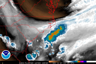 |
| Radar loop from 1145z May 6, 2007 to 0115z May 8, 2007 (Wikipedia) | | |
|
|
Huge bulging masses of air pushing other air masses out of their way aren't rare at all, but a mass that is so clearly defined as this one
is relatively rare, so I've slowed this down and doubled its size below so you can more clearly see the progression:
 |
| Same loop as above, slowed down and enlarged 2x (Created by me with two lines of imagemagick) |
I pulled some historical analysis charts from NOAA by going to
http://nomads.ncdc.noaa.gov/ncep/NCEP, selecting "United States Analysis" and then "United States Surface Analysis", then selecting the dates. I created another animated GIF with the surface analysis for the same time as the satellite images above so you can see what the strong low pressure system looks like on a chart and so you can watch that fat cold front march along to the south and start hugging little orphan Annie:
What I find as amazing as the clarity of that animation is that the phenomenon that started the whole process in motion was approximately 1500 miles away! Check out the first image of the surface analysis (which is posted by itself below):
 |
| Surface Analysis chart for 0000z May 6, 2007 |
See the high pressure (
H ) system on the east coast of James Bay in Canada? (It's at the top center-right; James Bay is the "tail" hanging off of the barely-visible Hudson Bay. It has a bold "1038" just to the right of it.) That H is the bulldozer that started the cold front in motion. Look at the animated chart again and watch the cold front start forming over Pennsylvania and central Ohio, then march mercilessly south, pushing everything else out of its way--including another cold front that wasn't moving fast enough. Once the east edge of the front's depiction line connects with the L off the coast, you can watch it start winding around it and creating an occluded front where Annie is. That L is about 1500 miles away from the H! It's not a coincidence that the Butterfly Effect was discovered by a meteorologist, although in this case we don't have a little insect flapping its wings: we have a big, fat, cold high pressure system plopping down and making a splash like a fat guy doing a cannonball into a continent-sized pool.
Most people tend to think of weather as local: if it's raining on their head, it might as well be raining everywhere, so local is about 10 miles. Pilots have a different definition of local, since we can be in another state in an hour, so we look at local as about 100 miles. As this example shows, weather patterns have yet another definition of local, which is about 1000 miles! Believe it or not, the weather in Ohio is heavily influenced by what is going on in the Gulf of Mexico south of Louisiana. The wind currents there can shoot bad weather up our way like a baseball being shot out of a batting cage machine, they can deflect it to the south of us by tugging a front down, they can intensify or interfere with fronts coming east off of the Great Plains, or any number of things. My next post will get into those large-scale patterns with yet another animation.
I'll leave you with another pretty picture of Andrea. This one even has some huge smoke coming from some brush fires in northern Florida to make it even more interesting:
 |
| Subtropical Storm Andrea on May 10, 2007 (Wikipedia) |


No comments:
Post a Comment